
In July 1869, George Davidson of the US Coast Survey and a small party of men climbed into several large cedar boats on the shore of Sitka, Alaska. The fleet was commanded by the celebrated Tlingit clan leader Kohklux; they were bound for his village of Klukwan, the capital of the Tlingit Indians of the Chilkat River valley at the head of the Lynn Canal. The travelers paddled as rapidly as possible, for they had a great cosmic appointment: on August 8, a total eclipse of the sun would sweep across the mountains and glaciers of the Chilkat valley. Davidson was to observe that eclipse, whatever it took to get there. As it happened, what it took was the friendship that developed between Davidson and Kohklux and his two wives, who were sisters from the Stikine River Tlingits. After the eclipse, these four people made a great exchange between themselves, to honor their experience. It came to pass that, 141 years later, a surrogate from that exchange finally returned to Klukwan. In August of 2010, Marsha Hotch, a Tlingit of Klukwan and a professor in the Native Languages Program at the University of Alaska Southeast, and her linguist colleague Alice Taff, viewed a digital image of the remarkable map of the Chilkat Tlingit world drawn by Kohklux and his wives for George Davidson.
To give context to this story for Expedition readers, it should be noted that the Tlingit leader who George Davidson knew as Kohklux had many names. Another name, the one most familiar to contemporary people, was Shotridge. When George Davidson returned to Klukwan in the early 1890s, his friend Kohklux/Shotridge was dead, but Kohklux’s descendants carried on his name. In Davidson’s photograph of the interior of the famous Whale House taken during that visit, the tall man in the center is Shotridge’s son, George Shotridge. Standing beside him is his son, Louis Shotridge, who became a prominent ethnographer associated with the University of Pennsylvania Museum.
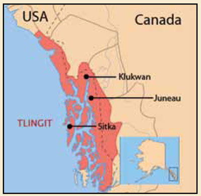
Why did George Davidson make such an effort to observe the eclipse in the first place? And why was the map made by Kohklux/Shotridge and his wives so valuable to him? The answer to both questions is that Davidson was a senior scientist in the Coast Survey. The Coast Survey, initiated under President Thomas Jefferson in 1807, is the oldest scientific agency in the federal government and continues today, now called the National Oceanic and Atmospheric Administration, or NOAA. Solar eclipses and the ebb and flow of the tides and the earth’s magnetic field were all part of the array of earthly phenomena the Survey had to examine and understand in order to map the coasts of the United States and prepare aids to navigation for ships in American waters. And in 1867, when the United States bought Russian America, now called Alaska, the Coast Survey acquired responsibilities to explore and map a vast territory drained by great rivers, with coasts and bathed by waters in an arc from the Pacific Ocean to the Bering Sea to the Arctic Ocean. And significantly, while it was terra incognita or unknown land to the Coast Survey, Alaska certainly was not so to its many native peoples. Nor was it unknown to the Russian colonists, British and French trappers, and a host of other people living there. The people made the land and waters theirs in part by naming their features. And the Coast Survey was unusually sensitive to the importance of Indian names on the landscape.
Davidson’s journey to Klukwan combined elements of what today we call macro- and micro- science. His solar expedition was one of four Coast Survey parties deployed to different parts of the eclipse path of totality across North America. Their common focus was skyward. At the same time, when Davidson first stepped on the river bank at Klukwan, it was his first encounter with the Alaskan mainland on North America (the Russian and later American capital of Alaska was on Sitka, on Baranof Island). Klukwan was the coastal terminus of an ancient trading trail and river travel system that arced over the mountains to the vast interior basin of the Yukon River. The place names along the way were both aids to the traveler, and also the legacy of thousands of years of cultures interacting over the great exchange between coastal and inland peoples.
The solar eclipse led to a remarkable intellectual potlatch (ceremonial exchange of gifts) on the shores of the Chilkat River in 1869. For Davidson and his party, the eclipse brought them to that paradigmatic 19th century state of the sublime; however, it was rather disconcerting for the Tlingit. But all were impressed that the cosmic event occurred right when Davidson said it would. In the days afterwards, Davidson made a painting on a cedar plank of the sun and its corona, as he had seen it at totality in his specially prepared telescope.

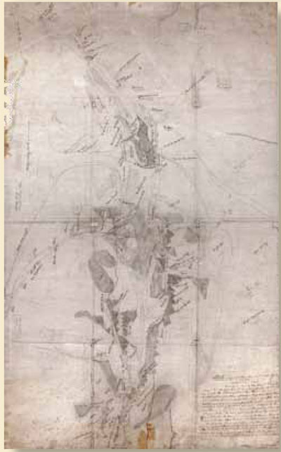
In exchange, Kohklux and his wives made a large map for Davidson, presenting the complex geography of the main ancient trade routes used by the Chilkat Tlingit. The areas on the map extend for 400 to 500 miles north and west from the Lynn Canal on the Pacific Ocean, up and over the great glacier-clad coastal mountain ranges, down tributary rivers to the main channel of the mighty Yukon River, to the British stronghold of Fort Selkirk.
No map can explain itself. During the three days it took Kohklux and his wives to draw it, the features and details represented on the map were a constant source of discussion. Davidson and the two wives from the Stikine River could converse at length, because as fully functioning adults in that era, they were fluent in the great Jargon, the Chinook and Haida Jargon metalanguage that had evolved in the convergence of mariners, traders, and warriors of the Pacific Northwest. In collaboration with the sisters, Davidson wrote down over one hundred Indian place names in at least three Indian languages, using English language spelling for the sounds.
The map was a major feat of cartography, but it was also the first experience of Kohklux and his wives with pencils. The lines are rather faint and sometimes blurred. Davidson asked permission to lay a Coast Survey translucent tracing-cloth overlay on top of the map, and then “pick up” the lines and forms in crisp ink. Then there was another round of inked place names written by Davidson on the tracing-cloth version. Some of the place names changed from the first map, as the sisters explained that, upon reflection, they had made errors in some of the names when first discussed.
Examination of a small portion of the great tracing cloth map shows the system of Tlingit cartography used by Kohklux and his wives. Lines represent rivers and tributaries, circles and other rounded shapes are lakes, and darkened forms represent mountain range ridges between valleys, with the shape of the undulating sides of the mountains showing the way the mountains look as seen from the adjacent river valleys. All place names were written by Davidson in his best approximation, using English language letters and accents, of the Tlingit names, and those in Han, Tutchone, and other Athabascan family languages described by Kohklux and his wives. In addition, here and there Davidson wrote brief explanations in English, such as the significant “Starting Point for journey to Yukon.” From that point, routes by water and land led to trading and rendezvous sites on the Yukon already in use for thousands of years before Davidson’s arrival.
Davidson himself never went to the lands on the other end of the Kohklux maps. Nor did his fellow Coast Survey scientist William Dall, who had explored vast areas of the lower Yukon River in the 1860s before joining the Survey in 1871. Dall later in life worked with the Smithsonian Institution (Dall’s Porpoise and Dall’s Sheep are named for him). In 1875, as part of the invention of what we now call anthropology, the great explorer and ethnographer John Wesley Powell published a monograph and map on the languages spoken in Alaska and adjoining territories, which was written by Dall, with assistance from George Davidson. The base map used was the Coast Survey’s second edition map of Alaska, finished in 1869, which incorporated the Alaskan geography Davidson acquired at Klukwan. Beautiful chromo-lithographic inks tint areas of Alaska’s vastness where languages from specific families of languages were spoken. Dall left blank the areas of the map where he and Davidson possessed no information. However, the routes and languages from Klukwan to the main Yukon River were clearly mapped—by Kohklux and his wives!
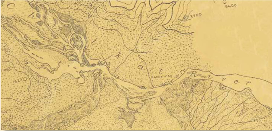
Apart from his brief visit to Klukwan and George and Louis Shotridge in the 1890s, Davidson never returned to the Chilkat River. The Coast Survey itself certainly did, mapping the Chilkat River valley with a large party, using other means of cartography. The Survey’s 1899 map of the Chilkat River valley, showing the rows of clan houses of the village of “Klookwan,” was made using stereo photography from a photogrammetric camera.
The first Kohklux pencil map stayed with George Davidson for the rest of his life, and is now in the Davidson Papers Collection at the Bancroft Library at the University of California at Berkeley, where it was re-discovered in the 1980s by Linda Johnson, the Archivist of the Yukon Territory. The tracing cloth Kohklux map was sent to Coast Survey headquarters in Washington where it was entered into the register of t-sheets (“t” for topography) as T-2268. It lay forgotten for the next 137 years. In 2007, while working as a NOAA historian studying the Coast Survey, I organized a project to acquire digital scans of historic—and relatively inaccessible—Coast Survey maps now in the National Archives II in College Park, Maryland. I was looking for early t-sheets from Alaska, knowing them only by their numbers in old registers. As soon as I saw T-2268, I knew I was in the presence of a masterpiece of indigenous cartography, and also a great story.
In 2010, Cheryl Oliver and her staff of the NOAA Preserve America Initiative Internal Funding Program (PAIIF) provided the funding and support to allow me to go to Alaska and the Yukon to take digital versions of hundreds of historic Coast Survey maps and charts “back home” to the people there. In September, I arrived in what is now Chilkat Indian Village. The sawtooth mountains fringing the great Chilkat River looked just as Kohklux and his wives had drawn them in 1869.
In a sense, the Kohklux map was now being repatriated to the Tlingit, just as many of the historic Tlingit collections made by Louis Shotridge for the Penn Museum have been or will be returned to the descendants of the people who made them. Marsha Hotch’s interest in the map is to determine precisely what roles it might play in the survival and renewal of Tlingit culture. So the map is now of a piece, for example, with the revivals of traditional Tlingit arts and technologies, such as the magnificent cedar boat newly made in the Klukwan workshop for traditional crafts.

One of my objectives in visiting Klukwan was to find out what happened to George Davidson’s painting of the eclipse, which is after all a major artifact of historic Coast Survey art and culture to NOAA. It had gone missing, and remains missing, but I was surprised and delighted by certain news, when I visited the staff and authorities of the Sheldon Museum down the Chilkat River in Haines, Alaska. Lee Heinmiller, an adopted Tlingit and Director of Alaska Indian Arts, Inc., told me that the cedar plank George Davidson had used was in fact the blank back side of a Tlingit Chilkat Indian blanket pattern board, used to design the legendary Tlingit woven wool blankets. That pattern board was a medium as specific and important to the Tlingit as was the Coast Survey’s high quality ragfiber drawing paper used by Kohklux/Shotridge and his wives. Thus the exchange of the maps and the eclipse painting was a potlatch on many levels.
Now that the 19th century Kohklux map has returned home, it can be used to promote Indian cultural revival and renewal in the 21st century. Doug Hitch, a linguist with the Yukon Native Language Centre in Whitehorse, Yukon Territory, suggested a trial application. He proposed we travel to the sites of some of the 104 specific place names on the Kohklux map, to see what we would find there now. In one lovely example, Kohklux and his wives mapped a distinctly egg-shaped mountain right on the Yukon River, clearly identified by Davidson as a mountain. As seen from the air, the great stone dome now known in English as Eagle’s Nest Bluff certainly looks as Kohklux and his wives drew it.
Doug Hitch is a specialist in the Athabascan language family. The mountain’s name in Northern Tutchone, Ts’al Cho An, refers to both the mountain and its immediate context across the river. This dramatic cleft in the mountains cut through by the great Yukon can be seen in the photograph taken from the nearest road to the site. The site’s Tutchone name translates as “The Den of the Giant Frog.”
The Den of the Giant Frog? What could such a marvelous name mean? It will take another trip to the Yukon to begin to find out. I have just received another NOAA PAIIF grant to return to Alaska and the Yukon during the summer of 2012. And I have since discovered many more historic maps and graphics to bring “back home” when I go.
-

- Lee Heinmiller of Alaska Indian Arts, Inc., holds the blank back side of a Chilkat Indian blanket pattern board.
-

- Doug Hitch, an Alaskan linguist, and the author stopped near Ts’al Cho An, on the Yukon River, in 2010.
-

- A portion of the tracing-cloth Kohklux map depicts an egg-shaped mountain.
-

- Ts’al Cho An, “The Den of the Giant Frog,” lies under the Yukon’s waters between the mountain on the left (which is seen from the air below) and the mountains on the other side of the river.